About The Crew

With great joy, we retired in 2006 and moved aboard our 35 foot Beneteau First 35s5 sailboat, DreamWeaver. We have spent every summer since cruising in the Pacific Northweast, from the San Juan and Gulf Islands, an area now known by its historic name of The Salish Sea, to Desolation Sound and the Broughton Group further north. In 2008 we spent the summer on a circumnavigation of Vancouver Island, a journey away from the boating crowds and into the stunningly beautiful wild coast and serene anchorages beyond our comprehension. In the winter we live in our house, Casa de los Suenos, in La Manzanilla, Mexico, a small fishing village on the Pacific coast. In 2010 we purchased a condo in Courtenay, B.C., once again establishing a land home in Canada.

Thursday, 30 June 2011

Juneau to Glacier Bay

Last Leg to Glacier Bay

The air drips thick with moisture as we leave Juneau. We dodge a massive cruise ship entering the harbour as we retrace our steps back to Stephen's Passage. By noon the sky brightens and a soft wind catches our sail on a following sea. We glide silently northward to Admiralty Cove, a pretty spot with grassy meadows. Perfect for grizzly bears (Alaskans call them brown bears).


                                            Lighthouse at Retreat Point, Chatham Sound
                                                            
The bears are a no-show but eagles are everywhere. We watch as one strikes the water to grab a surfacing fish. The eagle, however, does not take off again, but lies in the water, floundering. We have heard of this – the fish too heavy and the bird unable to release its talons. It either drowns or flaps its way to shore.

“Save it, Larry!” Pam calls out, not yet realizing that the other crew member lacks the courage to row over and grasp on to a thrashing eagle. But after disappearing momentarily in the water, the eagle flies off to a nearby tree, without the fish, where it sheepishly shakes the water from its sodden feathers.

Lazily, we pass the afternoon, reading and listening to whales blowing at the mouth of the bay. The sun slowly sinks behind the snowy mountains and we realize, with the long northern days, that the sky never truly darkens, even in the middle of night.
The next day's journey is thick with whales ..... and tour boats. We linger only briefly, not wanting to be part of the gawking crowd. As we round Retreat Point, the tour boats vanish in the distance. Melody, following behind, becomes surrounded by a pod of Orca, our first sighting in Alaska.

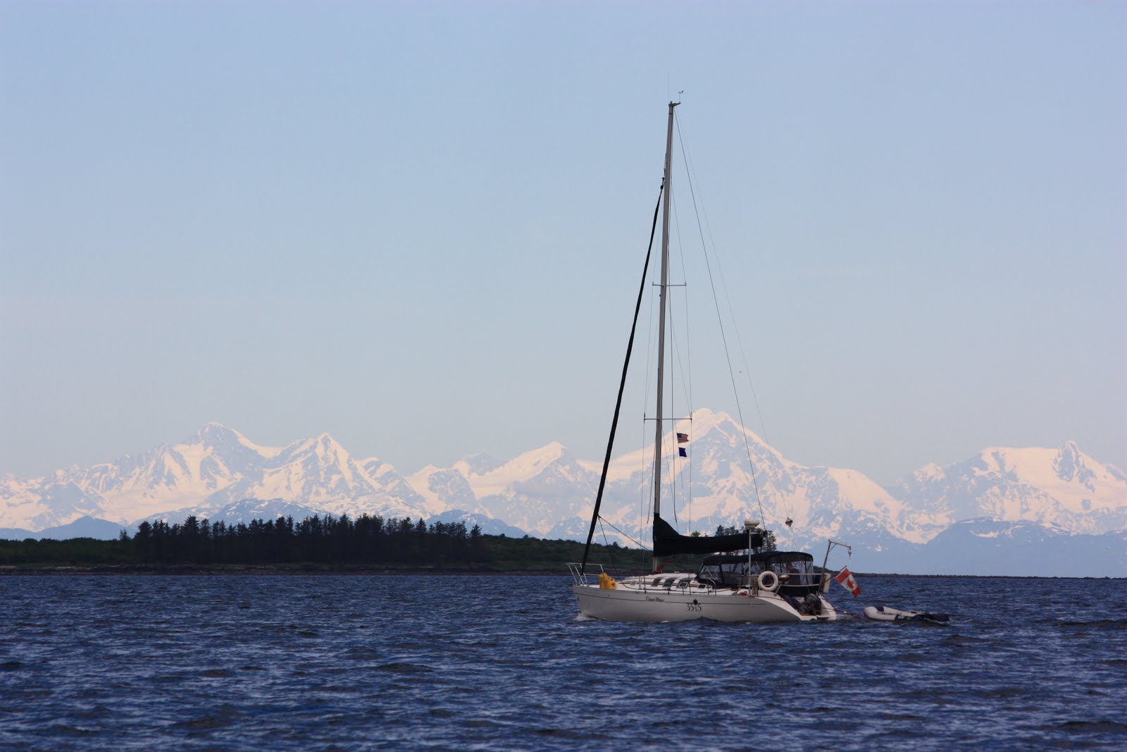
                                                          Feeding in Stephen's Passage
We arrive in Funter Bay for lunch .... lunch for the famous Alaska deer flies. They are everywhere, eager for flesh. Yikes! We zip ourselves in behind the cockpit enclosure and install the window screens.

It's showtime! The next morning, nine large humpbacks greet us at the bay's entrance and use the two boats as a centerpiece for their breakfast table. They roll out of the water, blowing jet streams high in the air, before lazily flipping their huge flukes and starting another deep dive. Sometimes, several heads emerge simultaneously from the water, like synchronized swimmers, before sinking back into their own turbulence. Salmon leap from the water, even though they are not the intended prey. We shut off the engine and drift among them, so thankful for this experience.


                                                          Humpbacks off Funter Bay

After making our way into rock-infested but beautiful Couverdon Bay for the night, we go ashore to pick sea asparagus for dinner. Meals on DreamWeaver are not too shabby. Pam bakes bread, muffins, cookies and gourmet meals. Having the freezer aboard helps. Often we share baked goods with Melody. That night, we have sesame/honey braised duck breast with stir fried garlic sea asparagus. Exquisite!

Icy Strait towards Glacier Bay 


Hoonah is home of the Huna Ttlingit (pronounced klink-it) people and the largest native settlement in Alaska. The name means “a place sheltered from wind”. It has a scruffy northern look and a lot of fish boats. Somebody told us that Hoonah had the best Halibut pizza in the world. Our search for this legendary pizza leads us to Capt. Dan and his wife, Hope, at the Misty Bay Lodge.  .

Huna Klingit Fishboat

“Just closed”, he says. “Electricity's too expensive to stay open if there's no customers”. We obviously looked devastated because he offers to drive up up the road to the competition. “Barb can cook anything”, he explains. Capt. Dan tells a story a minute on the short drive there. A true Alaskan. We don't see Halibut pizza on the menu there, but are introduced to Barb, the chef.

“Sure, I can make a Halibut pizza”, she exclaims. “What do you want on it?” We complete a negotiation on the ingredients and order up some Alaskan White Ale. If this was the “back-up” pizza, we'll have to come back for the real one. It was that good. An hour later we learn that Capt. Dan is waiting in the bar to drive us back to the dock. We are overwhelmed by the hospitality.

Back at the dock, our neighbour boat from Seattle has just caught a large halibut. With insufficient room to keep it, they give each of us large bags of fresh halibut. What a great end to the day.

After leaving Hoonah and overnighting off a shallow spit at Pleasant Island, we radio to Park Headquarters in Bartlett Cove to receive clearance to enter the park. After verifying our permit, they issue instructions.

“Stay one mile offshore, otherwise in mid-channel. Do not exceed 15 knots. Alter course if whales appear and maintain a distance of ¼ mile. Report for your orientation at 1100 hours.” We look at each other, feeling like army recruits in a boot camp.

But the orientation is warm and fuzzy, the pamphlets and video great and the long list of regulations reasonable. As it turns out, shoreline rules only applied to the “Blue Zone”, the first section of the park with a high concentration of feeding whales.

                                                        Mt. Fairweather in Glacier Bay

We're here!

Glacier Bay Wonders

Glacier Park is a 25 million-acre World Heritage Site and one of the world's largest protected natural areas. Less than 300 years ago it was completely covered by ice, a remnant of the last ice age. Because of this, it is a living journey back through time. As the glaciers retreat, leaving a landscape scraped clear to bare rock, one witnesses nature reclaim itself with different kinds of vegetation. The first growth to appear is lichen which looks like velvet covering the huge glacier rocks.
On our first morning in the park, the sun breaks through the cloud cover, illuminating the snow-capped mountains. They look like crystal lanterns strung in a row. After a 2-hour trip to the head of Giekie Inlet, we go north to John Hopkins Inlet, through ice floes to within 7 miles of the glacier of the same name. It is the only advancing glacier in the bay and is full of birthing seals. For this reason, it is closed to all traffic, although we don't think the thick ice would allow us further transit. The view, even from 6 miles away, takes our breath away.

                                                             John Hopkins Glacier

Two more glaciers to go for the day – Reid and Lamplough, then we snug in for the night behind Russell Island next to large shoal of gravel deposited by a now-departed glacier. The sound of cascading distance water falls lull us to sleep.

                                                     DreamWeaver at Lamplough Glacier
The next morning gets even better. We head into Tarr Inlet, smothered in crystal air and brilliant sunshine. Margarie and Grand Pacific Glaciers lay ahead. But first we must again navigate 6 miles of floating ice, slalom-like, sometimes coasting in neutral to avoid hitting ice with a spinning prop.

                                                        Close up to Margarie Glacier

Margarie is a 250 feet high and one mile wide, a stable glacier that flows into the sea at the rate of 8 feet per day, continually calving off its daily ice into the inlet. It shimmers shades of white and blue. We are careful not to advance too close because calving ice can create a tidal wave big enough to capsize a small boat. We shut off the engine and drift in silence, that being broken every few minutes with thunder-like cracks and explosions within the ice as the stress of glacial movement gives way. We realize now that the thunder we thought we heard last night was actually the glacier, 6 miles away.

Adjacent is the Grand Pacific Glacier, which recedes 35 miles back into Canada. Its face is black and sinister looking because of the silt and rock it leaves behind as it recedes. Its beauty is in the swirling ice currents that flow around the encompassed mountains, making it appear extra-terrestrial.

                                          Looking into Canada past Grand Pacific Glacier
Back in our earthly reality, we note from our instruments that our global position is latitude north 59 degrees 62 minutes, our most northerly route in our journey. We have traveled 1350 nautical miles since home port.

We anchor in late afternoon in Blue Mouse Cove, looking across at the soaring peak of July Fourth Mountain. A large grizzly bear ambles along the rocky shore, a lone humpback feeds off our port side and two harbour porpoises cruise by. Like a nature show. That night, clouds roll in and a soft rain begins to fall. Mountains recede into the mist grey predominates. We decide that the next day is one of non-travel. No sensory stimulation, just lolling in the cockpit resting. 

However, the whales have other plans. A mother and calf enter the cove to feed for the day, cruising a pattern that often brings them close to DreamWeaver. Each time we scramble, camera in hand, looking for the National Geographic photo. But the whales always take us by surprise, going deep, then shooting out of the water close by, mouths open or giant flippers waving. The shutter clicks on empty water. A calf breaks away and heads for the boat, We see his body just below the surface alongside DreamWeaver, he pauses and moves to the stern. Pam yells, “Oh my god! Oh, my god!”, as his 35 feet brushes by, inches from our hull.

                                                                         Sail Past

"Look at the baby", she calls out.

"That's the baby?" Larry answered. "There's a bigger one?

Part fear and part exhilaration as we watch in awe as the baby reunites with his mother. We believe he was as startled as much as we were.


                                                     Close Encounters of the Whale Kind

As if that is not enough two more whales come in, another mother and calf. The show extends into evening, nearly 4 hours of feeding and watching these magnificent mammals eat their fill.  Terns squawk and hover over the whales as they stir up food for them. We settle down in the aft cabin, nestled in with our books, and hear one last spout of a whale perhaps saying 'good night', then all is quiet.

By the 4th day in the park, the weather continues to worsen, so we head back to Bartlett Cove in preparation to head south. We feel that we have seen everything, in the best of conditions. But the park has one more presentation. Marble Island has a large colony of Steller Sea Lions, as well as hundreds of Pelagic Cormorants and Arctic Terns. We hear the sea lions before we see them – roaring, snorting and grunting. They look like large brown sausages lolling on the rocks, the huge 2000 pound males in the centre, bellowing loudly with heads held high. Kings of the rock. The younger ones frolic in the deep water, leaping and twirling, like ballerinas. A young male – a sentry? - swims to the boat, looks us straight in the eye and snorts loudly. “Piss off!”, he seems to say.
 
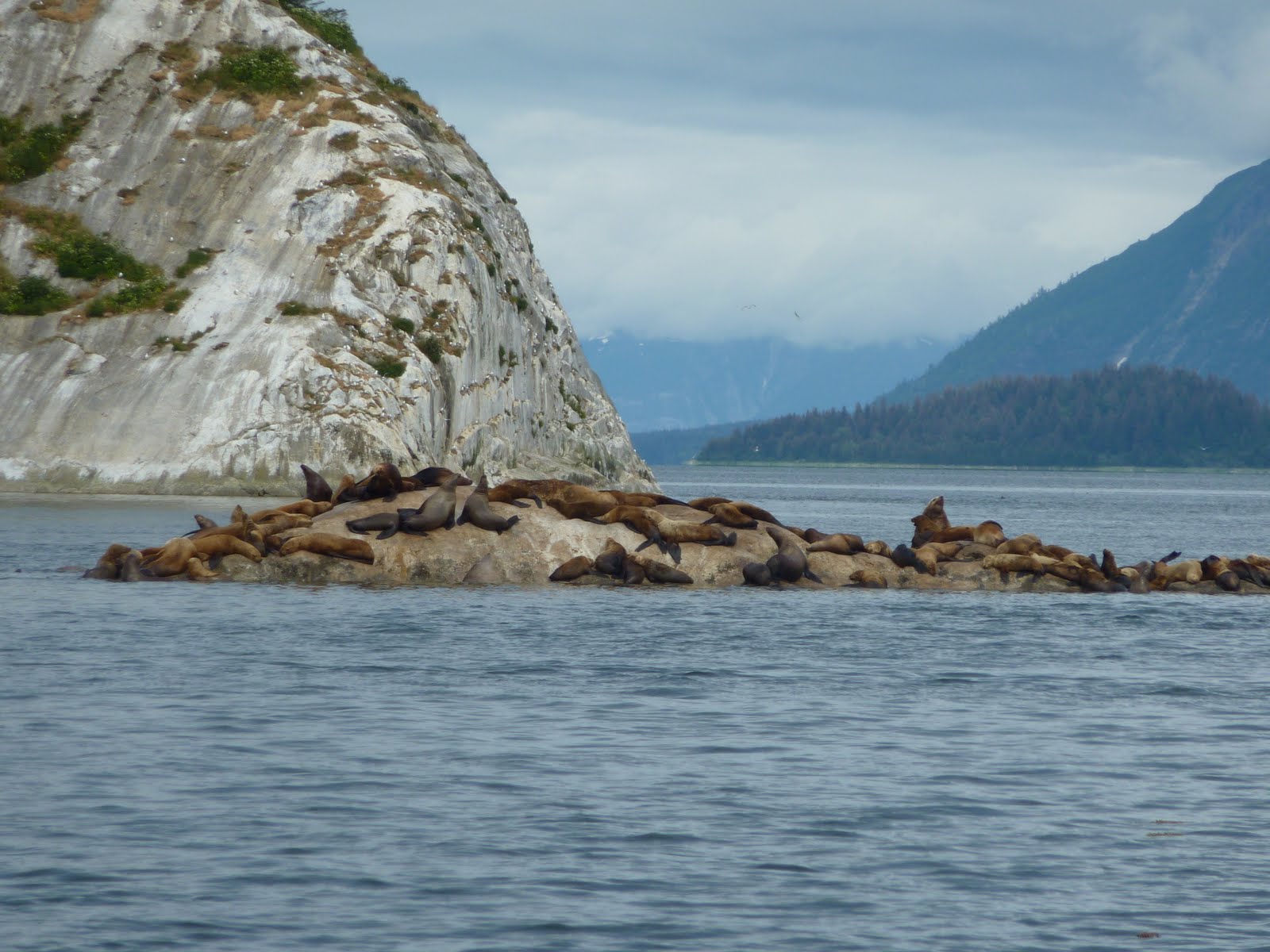
                                                           Marble Island - Glacier Bay
We pry ourselves away, and pass back through the Blue Zone, dodging countless whales, who don't seem to respect the “boat zone”. It's Helen's birthday, so we walk the nature trail and enjoy a meal at the Glacier Bay Lodge.

The next day, the winds have reached 20 knots, with tidal conditions that prevent our planned trip west out to Cross Sound and the open ocean side of Chichagof Island. We stay in port to wait it out.

Glacier Bay has more than met our expectations. It was worth the many long days and miles of travel to reach this destination. Pictures and words cannot fully convey the wonder and awe we have experienced within Glacier Bay. It is a memory deeply embedded to bring out at future times when we reminisce about this magical place where evolution is occurring before our eyes.


Sunday, 19 June 2011

Ketchikan to Juneau


Wrangell

With over 300 miles to Glacier Bay we are happy to leave Ketchikan and resume our progress northward. Low cloud and drizzle are creeping in, so we decide to leave the larger Clarence Strait, where waters can get rough, and take the less traveled route through Ernest Sound, then up through Zimovia Strait to Wrangell. Wrangell looks and feels like the wild west as the name might imply. The Tlingit Nation occupied the site for generations, before the arrival of the Russians, British and then Americans. Being situated off the delta of the Stikine River, it became the gateway to several gold rushes. We stay overnight at the dock, explore yet more totems and have bad pizza in an dark, stuffy American-style bar. All part of the experience.

                                                                                    Tlingit totem in Wrangell

Leaving the harbour in the morning, the water turns from icy green to murky brown, as if someone had drawn a line through the water. This is due to the silty runoff from the mighty Stikine River. These unusual sea colours are due to the fact that fresh water floats on salt water, so we are always sailing over the top layer of fresh water. We speculate that the boat must travel faster in the less dense fresh water.

Two hours later we enter Wrangell Narrows, a 22 mile narrow, twisting waterway with fast currents and turbulent rip tides made worse by the huge spring tide changes of almost 20 feet. With 66 channel
markers to negotiate, we feel we are in a real life video game of Pac Boat. As luck would treat us, we don't encounter the expected Alaska State Ferry, which occupies the entire channel on its trip through.

                                                                  Negotiating the Narrows in the mist and rain

Petersburg

Facts about Petersburg. Annual precipitation is 109 inches. That's wet. In late June there are 18 hours of daylight (Pam wears a eye mask in order to sleep). Norwegian is cool. Fish rule.

Of course we arrive in the rain and set out to explore the town of 3000 people. We ask about all the Norwegian flags and are told that Norwegian settlers first came here in 1897, attracted to the very lucrative fishery. The harbour master tells us that most people who come here eventually become Norwegian. But back to fish. The town smells like fish, and fish boats come and go constantly, disgorging their catches. We set off to find fresh halibut for dinner, but find the price is $25 per pound. Huh! We left the dock without halibut. Later, we sit in the cockpit, looking at the grimy dock, taking in the scene – fishermen yelling back and forth to each other with cheerful banter, motors from the processing plants humming, the clanking and banging of tools making repairs. Is this the real Alaska?

While enjoying our glass of wine at “Yard Arm” (theoretically, the end of day drink happens as the sun passes over the yardarm but have adjusted the time drastically to suit the needs of the retired and the Alaska daylight hours), we realize that we have now passed the 1000 mile mark, which represents over 200 hours at the helm. Unlike open ocean cruising, one really does have to be at the helm at all times. Speaking tedium, we wonder what life is like in the winter in this rough-edged town, where isolation, constant rain and long dark nights must cast a gloom over the human psyche.

The following two days it rains. We bail 20 liters of water from dingy twice a day. In Portage Bay, huge 10 meter long seaweed drifts in, wrapping itself around anchor chain and rudder, requiring the use of the boat hook to unwrap the long tendrils. We decide to stay there the day, taking a “weather day” because the heavy rain makes navigation difficult. But by afternoon, the rain stops and we catch a fast current north, making 8 knots to Cleveland Passage.

Leaving there the next morning, the clouds pull back, allowing the sun to dry the sodden air. Two pair of Humpbacks feed off our port and starboard , their giant flukes gracefully sliding under the glassy water. Later, a pod of Dall Porpoises converge on us, taking turns to “ride the bow”, a playful ritual whereby they swim inches off our bow, just under the surface, then breaking out to leap out of the water. Larry dances on the bow with camera, trying to catch a photo, while Pam frantically points in all directions, trying to keep track of our fast moving friends.

                                                                  A daily occurrence – the fluke of a humpback

As we enter Tracy Arm, we are greeted by large chunks of floating ice called “Growlers”, small icebergs up to house size. Tentatively, we creep closer to take a photo of the crystal green translucence of a bigger one. Hundreds of Harlequin ducks and a large group of bald eagles greet us into the anchorage at the mouth of the arm. This will be our “base camp” for the next day's 10-hour round trip into Sawyer Glacier. In Tracy Arm there are no anchorages.

We pray for sun the next day to view the glaciers, as most boaters experience heavy fog and rain. The gods bless us again - at 5 a.m. the sun streams into the cabin, gently waking us. We negotiate around a large growler to exit the anchorage.. Camera shutters click. Over the next few hours the ice pieces increase in number, including thousands of “bergy bits”, smaller than growlers, but still big enough to do serious damage to propeller or rudder. Massive rock walls rise on both sides of the channel. 


                                                               Tracy Arm with M/V “Swell”, a dive boat from Nanaimo


                                                                                Tracy Arm - pausing to reflect


                                                               Amidst the bergs in Tracy Arm – Sawyer Glacier

By the time we reach the fork in the channel, it is apparent that the channel to North Sawyer Glacier to blocked with ice. Melody tries a north route to get to South Sawyer and we try the south. They disappear and reappear amongst the ice. Black spots on ice floes turn out to be seals giving birth to pups. We creep closer, in awe at what we are experiencing.

                                                                    Seals birthing at foot of Sawyer Glacier


                                                                                      Seal with new born pup

North Sawyer Glacier comes into view, as high as a 30 story building, like a crystal dragon creeping through the mountains to the water's edge. We shut off the engine and drift silently among the ice floes. It's like floating around in a giant margarita. We do not talk – there is nothing to be said.

Our two boats eventually reunite and we sit, floating, engines silent listening to the crackling of the icebergs shifting and breaking around us. We do not want to break the spell. Around the corner, not 500 meters away, the bow of a huge cruise emerges grotesque in its size in such a beautiful place. The name is Carnival Spirit. We all laugh - the spell is broken, but not forgotten.


                                                                                        Eagles on a cool perch

The next day, we weave around a large iceberg upon which 9 eagles are perched. Click! Click! Then another pair of humpback whales. Not wanting to arrive in Juneau in late day, we stop in Taku Harbor. Being Friday night, the dock fills up with week-enders from Juneau. It's party time at the dock. We get in the spirit, as does a brown bear, who hovers around the top of the dock ramp. What fun!
To get into Juneau we must pass under a bridge that specifies a 52 foot clearance on the chart. Our mast is 52 feet high, so we read what information we have in order to find out what this means. 52 foot clearance at low tide? High tide? Oh, but Americans calculate tides differently than we do, and for the life us we can't figure it out. A local at the dock advises that a recent survey of the bridge discovered that the clearance was actually out by 2 feet but she couldn't remember which way the error was. Alas, a sail boat arrives skippered by the just retired Juneau port manager who explains everything to us. We'll be fine at the minus tide for next morning.. Everyone groans because low tide is at 0930 so we have to leave Taku at 0600 to get there in time.

Juneau is the capital of Alaska. It's busy with fish boats and cruise ships, but otherwise drab on a rainy day. But the laundry is done, the galley restocked, the cabin vacuumed,and water and fuel tanks filled. Tomorrow we begin the last leg to Glacier Bay, with lots of time to meet our June 25th entry date.


Thursday, 9 June 2011

Finding the Real Alaska


It is over 100 miles from Prince Rupert to Ketchikan, the Port of Entry into the United States. Dixon Entrance can be a nasty piece of open water and our slow speed forces us to cross it over two days. In our case we stop overnight at Dundas Island before completing the crossing in advance of predicted bad weather.

After an 8 hour run under power and sail we reach Ketchikan and check into customs. We had to purchase a “cruising permit” and, as a foreign vessel, were now required to report into every major port we stop at while in the state. Homeland security and all that.

Entering Rudyerd Bay

Ketchikan is a boom to bust town of somewhere between 5 and 10 thousand people, depending on the time of year. Gold, fish and logs came and went, and now they mine for gold in the pockets of tourists, thousands of them who arrive by cruise ship, usually six a day. These are huge floating hotels which spew out thousands of tourists each day into the streets. They are met by dozens of teeshirt and jewelry shops, art galleries, tour companies and suspiciously new-looking historical buildings. The huge number of jewelry shops is startling. The whole surreal scene begs the question - what Alaska are tourists really looking for?
We strike out in search of something real under the glitzy surface and strike gold. The friendly barkeep at the Red Snapper Bar, where we stop for a pint of Alaska Amber. She describes herself as a typical Alaskan – a transplant from the south, liking the natural beauty but concerned about the high levels of drug and alcohol addiction, and angry that so many foreign owners reap the profits of the tourist trade and take it with them when they leave after the season.

Alaskans don't like the government – any government. On a city bus we sit across from an old guy with a husky at his feet who you'd swear just stepped out of the bush after a month panning gold. After a 10 minute dissertation on the evils of government, he waves back to us as he gets off the bus and yells, “In Alaska we don't say goodbye unless you work for the government”.

We stop to talk to a native gentleman painting a design on a war canoe paddle. He gives us a lesson in aboriginal history. His great grandfather was a Tsimshian who fled to Alaska in 1862 to escape poverty and feuding missionary groups in Canada, preferring instead to face the lack of welcome from the local Tlingit people.

We did visit, by bus, Totem Bight Historical Park complete with beautifully carved totem and a replica clan house and further south on Tongass Narrows to Saxman, a native community, with a historic totem sight with a clan house in use and a carving shed.

Having discovered some real Alaskans and visited historic totem sites, we cast off the dock the next day and start the 150 mile circumnavigation of Revillagigedo (say that fast) Island. This takes us up the Behm Canal to the Misty Fjords National Monument, where most boaters don't get to because of its off-the-beaten-track remoteness. The attraction is Rudyerd Bay and Punchbowl Cove, a narrow 5-mile long fjord sided by sheer rock cliffs that soar over 3000 feet high. These were formed when the land mass of North America collided with the ocean floor over 100 million years ago. Or so we read. The water here is milky green and waterfalls cascade hundreds of feet down the vertical walls. Like another planet! Few people get to see the Misty Fjords in the sun. As Pam is fond of saying – We are blessed.


Melody in the Punchbowl

It's too deep to anchor here and we retreat to Manzanita Bay. We try to anchor in 80 feet but snag a submerged tree on a rocky bottom – not good. Did we mention that our windlass, that back-saving piece of machinery that pulls up the anchor and chain, seems to be giving up the ghost? So we trace our steps back 8 miles to Shoalwater Passage, where a serene, eerily quiet bay, punctuated by the hoots of a Great Horned Owl, awaits us. We declare “Yard Arm”, that time of day for a glass of wine when the sun sets over the yard arm of a sailboat, adjusted quite liberally for the extended Alaskan day.

We pass by New Eddystone Rock, a lava pinnacle named by Captain Vancouver when he was up Behm Canal looking for the Northwest Passage. It reminded him of Eddystone Rock in Plymouth, England. Apparently the glaciers could not grind away the hard lava conduit that was part of an ancient underwater volcano. Of course he never found the Northwest Passage.

Behm Canal

The next 3 days wash by us and the weather holds. Yes Bay (pronounced 'yass', meaning mussels in Tlingit) puts on a nature show – a large black bear feeds on the river delta, then a grizzly bear makes its way to the grassy shore to roll and frolic, the end of day descends with the eerie calls of a lone loon as the sun sinks behind the mountain.


Rudyerd Bay


We are running low on fuel and have dipped into our reserve containers strapped to the deck, which forces us to complete the circumnavigation and return to Ketchikan. Tomorrow we will recommence our journey north to Wrangell. We are now 2/3rds of our destination – Glacier Bay,

Thursday, 2 June 2011

The Inside Passage

Rounding the Cape

To reach the “Inside Passage”, vessels must leave the relative calm of Queen Charlotte Strait and travel the open waters of Queen Charlotte Sound, where 8 foot swells test the endurance of boat and crew. Cape Caution looms ahead, as well as other daunting place names – Fury Cove, the Storm Islands, Grief Bay. Here, winds and currents can change suddenly to create dangerous and uncomfortable conditions. But for us the Cape is calm and the shoreline sparkles under the sun which struggles out by midday. Reaching Miles Inlet for the night marks the official beginning of the Inside Passage.

The Inside Passage

The Inside Passage is a complex maze of channels, passages and islands which thread up the coast of B.C. and the Alaska Panhandle. Deep inlets slash into the mainland, snow-capped mountains line the narrow fiords, and spring runoff creates endless cascading waterfalls into the sea. While safe from the violence of the open sea, funneling winds, strong currents and numerous rocky reefs make navigation challenging. We are thankful for the modern navigation instruments we have on board, in particular the GPS Chartplottter which locates our boat to an exact position on the globe, displayed on proper navigational charts. It also maps the profile of the ocean underneath us, so we always know of the hazards that lurk beneath.


Our anchorages are unforgettable. Fury Cove, in spite of its name, is a calm and serene spot with a bone white shell beach, although a 3-minute walk across to the Fitz Hugh Channel side reveals a twisted log strewn beach, evidence of stormy days. The following day we detour up Kwakshua Channel to Hakai Passage, anchor for lunch and then take a short hike to a gorgeous beach overlooking Queen Charlotte Sound. The sand is silky soft, like flour, the sand dunes at high tide lined with wild strawberry in bloom. Wolf tracks snake down the low tide line and rocky islets lie a short distance off-shore. This is Canada at its best.

On our 8th day we reach Shearwater during a light drizzle to refuel and purchase a few provisions. We have traveled 370 miles – over a third the way.

North to Prince Rupert

In the days that follow, the two boats settle into a routine, weighing anchor around 0600 in order to take advantage of the favourable currents, which can easily add a knot or two to our cruising speed of 6 knots (one nautical mile is slightly more that one mile on land). The weather improves, and the sun emerges each day by noon and, because of our early starts, we are able to drop anchor by early afternoon and enjoy the warm afternoons snoozing and reading in the cockpit.


We pass out of the ancestral homeland of the Kwakiutl peoples and into Tsimshian territory. The village of Klemtu appears busy and prosperous, its beautiful long house indicative of a community proud of its heritage. The mountains get higher and snow pack lower. We see our first grizzly bear, with cub, as we anchored next to a cascading waterfall in Khutz Inlet. Larry was out in the dingy close to shore when man and beast made eye contact, at which time the bear ran full tilt towards the shore, with man paddling furiously away from shore. As it turned out, the bears were trying, successfully, to reach the safety of the river, where they swam to the other side and into the trees.


One of our next stops in Bishop's Bay. Pam says it's named after her grandparents .... right! Fresh caught crab and chilled chardonnay for lunch. Anyway, there is a lovely hotsprings there that has been developed, as in small dock, change “house” and concrete walls on the two pools, each a different temperature. We forgot swim suits!!! But wait until the coast is clear and go au natural. After a long soak, we sleep like babies, even though there is a chop banging on the boat.

Exiting Douglas Channel after refueling in Hartley Bay, Larry is startled at the helm as 3 humpback whales leap from the water in unison about 200 feet off the bow. We try to get a good photo, but often one misses a great emotional experience by fiddling with a camera. We watch them feed for a while, satisfied with our nature experience for the day.

Nettle Bay offers up another waterfall, lots of bird life, an ancient fish weir, and the wharf remains of old fish cannery, one of dozens that once dotted the coast before mismanagement destroyed the resource. The four of us take a short hike to view the roaring falls.


The weather continue to bless us, with sunny warm days. We can't believe it. We slow down our pace because we are making such good time. Our last night before Prince Rupert is Klewnuggit Inlet, yet another place name starting with “K”, indicative of the native languages once spoken here. The last leg is mostly in thick fog that the sun cannot burn off until noon. The radar is a blessing, but can't see the numerous logs that float about, many big enough to damage a small vessel. Exhaustion quickly sets in as the helmsman constantly watches radar, GPS, compass direction, all while straining to peer ahead into the fog.


We arrive in Prince Rupert, a harbour busy with boats, ships, and seaplanes. The marina is a welcoming stop, and we go about our individual tasks – shopping, internet, change engine oil, laundry and needed repairs to a windlass that is labouring. Larry spent 4 hours trying to fix the windlass, a rather essential piece of equipment for an aging crew with bad backs. We have reservations at the Cow Bay Restaurant, a small seaside place with home cooked meals. Yum!

We have now traveled almost 600 miles more than half way. Tomorrow we leave for Alaska. Ketchikan here we come!

Sunday, 22 May 2011

We're Off

Exhausted after hours of planning, buying, hauling and stowing provisions and equipment, we cajoled DreamWeaver off the dock late afternoon on May 18. She was sluggish from the weight of full water and fuel tanks, and weeks worth of provisions. The short shakedown cruise from Ladysmith to Nanaimo revealed no issues; short of a constant worry about what we may have forgotten. And of course we did - the Ipod, which happily turned up two days later.

From Nanaimo we rendezvous-ed with Bob & Helen aboard Melody at 0700 and motored across the Salish Sea where the Sea gods, Salish ones in this case, blessed us with sunny skies and light NW winds. However, one rule of the sea is that no matter which direction you travel, the wind blows against you - the Sea God of Contrarian Direction. Motoring against the wind is much faster than tacking into it, but is hard on the crew and boat. Amani hates the slap of the boat against the waves and cowers in the aft cabin until she hears the silence of the engine.

We anchored for a quiet night in Sturt Bay, Texada Island. Off to the pub for a good brew, burger and social time with Bob & Helen, as well as discuss our plans for the next few days. This is really about deciding where to get to each day and which routes to follow - all dependent on weather and sea conditions present. Of course you can plan and schedule all you want but the decision always rests with the sea.

We awoke to calm seas, clear skies, and summer-like temperatures. We headed north to Francis Bay, Raza Island where we settled for the night awaiting slack in the morning. As we sat in the our cockpit enjoying the warm temperatures, we watched as 3 eagles swooped down; one to grab a juicy red snapper out of the water. Another struggled to get out of the water after failing to get its chosen prey, to be seen afterwards drying its wings before the sinking sun. It's scenes like this we do this for.

Transiting Rapids
The general rule is to transit fast flowing rapids only at “slack water”, when currents stop flowing briefly. In this case there are 5 sets of rapids. The first, Yuculta, is taken 30 minutes before slack just before the current changes to an ebb tide, meaning you will then be going with the current. This gets you through very fast but gives more control of the boat over to silent prayer. The second set, Gillard Passage, is 10 minutes further – perfect! The 3rd and worst one is 30 minutes farther but the timing is good and the current is nicely with us. The challenge is the 4th, 2 hours away and flowing fast at 5 knots when we arrive. On the ebb tide we go for it, and hurtle through at 10 knots, bucking the violent twists and pulls of the swirling water. Two hours further is Whirlpool Rapids but it is slack water again and we are safety through.

Grumpy Johnstone Strait
Most boats stay the night at this point in Forward Harbour, waiting to see what morning will bring before heading out onto “the Strait”. Getting through “the Strait” to northern waters has 2 routes – straight up the strait if weather is good, or through the “back door”, a series of channels that hug the mainland, longer but protected.We plowed on and made it through until Port Nelville before “the Strait” lived up to expectations and forced us in with increasing head winds and high waves. By now the expected cloud and rain began.

 The next morning we went straight up, avoiding the longer route, and were blessed with calm seas and sunshine by early afternoon. Staying at dock that night was a well-earned reward for a fast passage north, as well as a chance to replace a forgotten pepper grinder.  Melody invited us aboard for seafood chowder and good company. 


We are now 180 miles into the journey and only have 820 miles in front of us to reach Glacier Bay. Oh my! But we feel like we have come home when we are on the seas. Our vagabond natures come out and we find a simple rhythm in our daily lives.

Monday, 16 May 2011

Welcome to our Journey

Three years after our circumnavigation of Vancouver Island, DreamWeaver and Melody, a 36 foot Islander crewed by Bob and Helen Manning of Nanaimo, B.C., will again cruise together to Glacier Bay, Alaska via the fabled Inside Passage, a nautical distance of about 2000 miles roundtrip.

Here's our theme song.  http://www.youtube.com/watch?v=JSt0NEESrUA&feature=related

Our plan is to go straight there, taking advantage of prevailing southeast winds, then taking time later in summer when the weather is warmer to leisurely explore the coastline and inlets on the return trip. Hopefully our diet will shift more towards fresh-caught fish, crab and prawn. If weather patterns hold true, the winds will shift to northwesterlies, allowing us to sail much of the time. 

"Let's go to Alaska", Pam blurts out last summer

With an average "speed over land" of 6 knots / hour, 7 hours per day average, we hope to reach our destination in approximately 30 cruising days, allowing for 10 non-travel days built in for: rest, bad weather or, God forbid, mechanical problems. 

We have secured permission to enter Glacier Bay on June 28 and will be allowed to stay up to 7 days. They are very strict about the number of boats allowed entry to protect the fragile ecosystem.   Each skipper must undergo an orientation  prior to entering the bay.

Over the past few weeks we have been busy preparing for this journey - adding more chain to the anchor rode, installing a new GPS and e-charts,  buying more paper charts and tide/current tables, another crab trap, new starting battery, fishing license and gear, high capacity freezer, and doing the usual general maintenance of the boat.   

Back at the condo, we have provisioned the boat with homemade tomato sauce, chili, chicken/vegetable broths, mango chutney, packs of chicken, fish, and freshbaked muffins.  All this is necessary because of the limited supplies one finds in coastal community stores.

Amani has been busy preparing her fur coat for the cold days and reminding us to ensure she has enough food, treats and kitty litter to see her through the long journey.

                                                            Amani, the ship's rat catcher

May 18:  DreamWeaver casts off the dock at Ladysmith to go through Dodd Narrows at slack water (water will be calm as the tides are changing) to meet up with Melody outside Nanaimo Harbour. Depending on weather and winds, cross Georgia Strait and anchor in False Bay, Lasqueti Island.

May 19: Travel north through Desolation Sound area into Squirrel Cove, Cortes Island, Desolation Sound, anchoring for the night.

May 20: Continuing north to transit Yuculta, Gillard Passage and Dent Rapids (see note below) at first slack and continuing to Shoal Bay to overnight.  
  
May 21: Transit Greenpoint and Whirlpool Rapids rapids to overnight in Forward Harbour. If weather and time permits we may instead proceed down Sunderland Channel and into Johnstone Strait.  Johnstone Strait is always an anomaly given the tidal currents and winds that can blow up to 50 knots. Good conditions may allow us to get to Port Harvey or Lagoon Cove, a point at which we will be able to do a Blog update.


Tidal Rapids

As tides ebb and flow, huge quantities of water are forced through narrow passages between land masses. This creates river-like movement of seawater, with currents that exceed the speed of many vessels, powerful whirlpools and strong undercurrents and back eddies. Boats can be forced, out of control, onto rocks or literally sucked under. A vessel's crew must carefully plan to transit these passages at "slack" tide, a short period of time when the water is calm, flowing neither in nor out.